A challenging take on a classic crossing
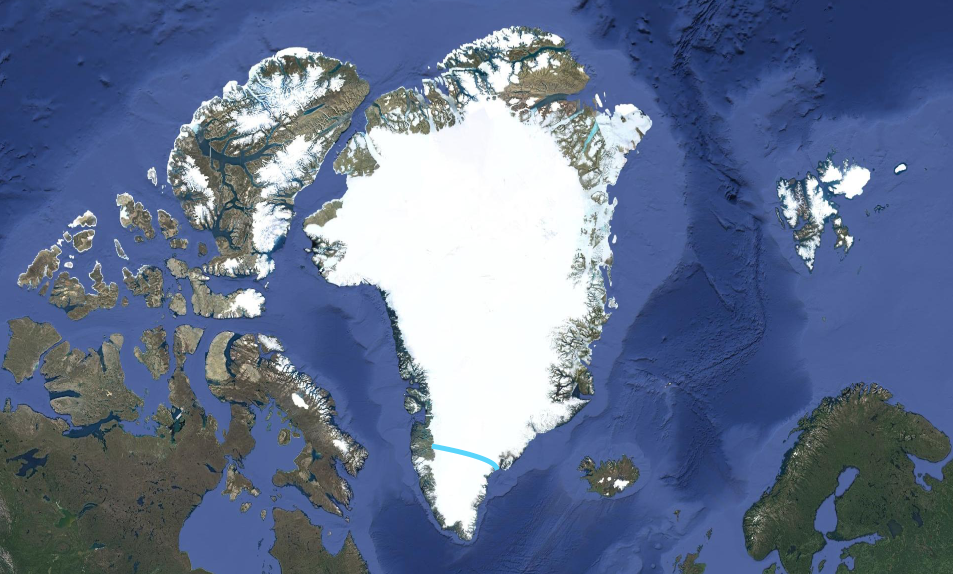
- Gateway Tasiilaq, Greenland
- Distance 540km
- Days on Ice 23-26
- Daily Distance 20km
- Temp. Range -5 to -25°C
- Sled Weight 70kg
- Challenge 5 What's this?
- Conditions Altitude, cold, wind, wet
- Challenges Altitude, cold management, sled hauling, icefalls
Trip Itinerary
Arrive in Tasiilaq and meet the team. Packing, preparation and purchasing final supplies. Welcome dinner at a local restaurant.
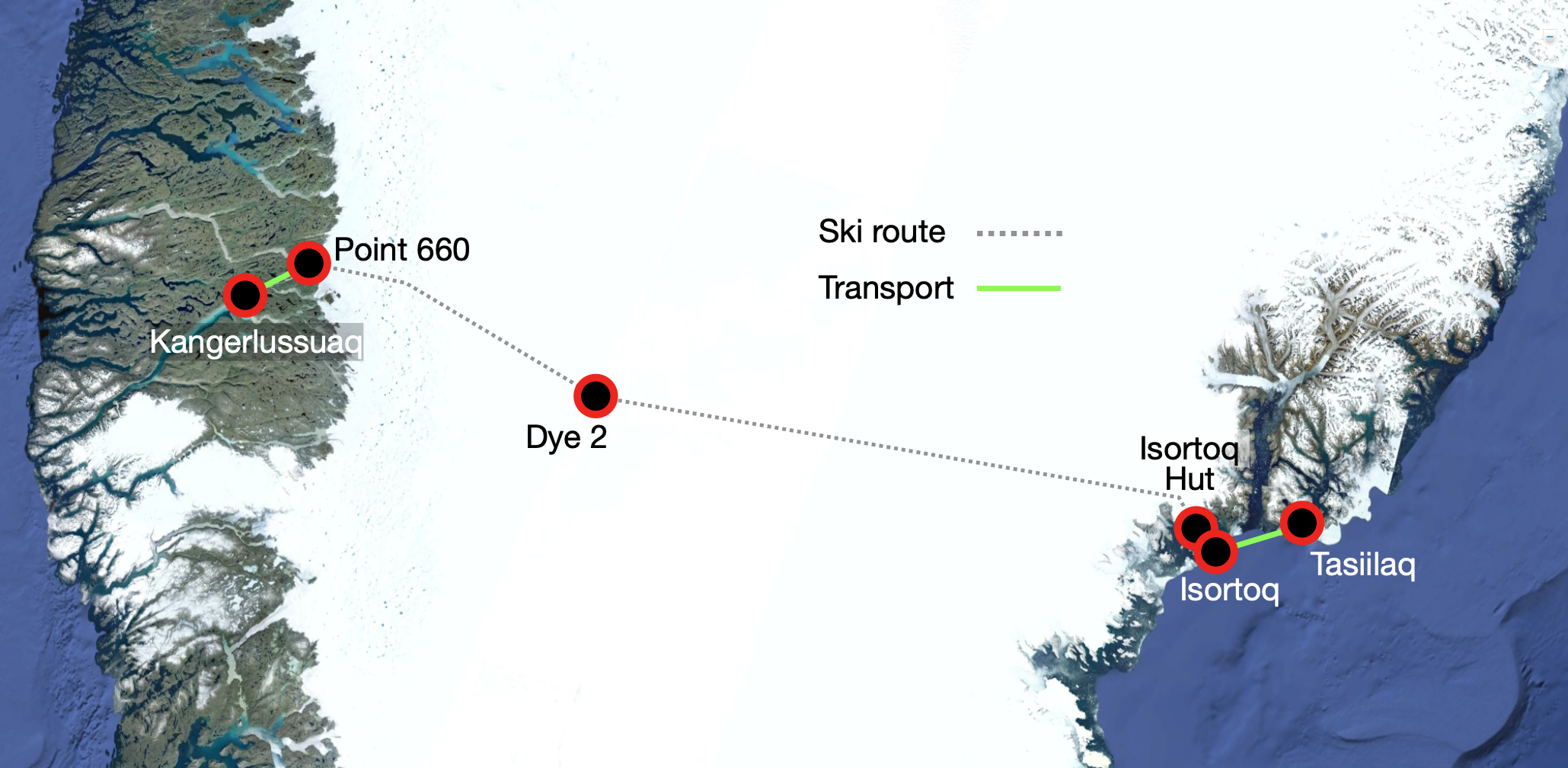
Boat trip to Isortoq, the start point of our expedition.
Starting on foot and moving to skis when possible, we navigate the challenging terrain of the lower icefall.
Continue a slow ascent to the reach the high point of our Greenland crossing, taking a rest day if needed.
Ski across the plateau towards DYE 2
Spend the night at day at DYE 2 taking some time to recharge, explore and check over our equipment.
Continue across the plateau and reach the icefall.
Navigate our way through the riverbeds of the icefall, stepping off the ice and onto land where we are collected by car and driven to Kangerlussuaq. End of Services.
Inclusions
- Boat ride from Tasiilaq to Isortoq
- Food and stove fuel while on the ice
- Icetrek guide(s)
- Use of technical equipment including sleds, tents, cooking equipment. This equipment is returned after the trip (see equipment list)
- Safety/navigation/communications equipment
- Mandatory search and rescue insurance
- Transport from finish point to Kangerlussuaq
- 20% discount on selected Icetrek Equipment
Exclusions
- Travel to Tasiilaq
- Accommodation and meals in Tasiilaq
- Accomodation and meals in Kangerlussuaq
- Additional costs (accommodation, meals etc.) due to changes beyond our control ie. weather delays
- Evacuation, hospitalization and repatriation costs and/or insurance (we can advise)
- Personal clothing and footwear
We meet in the picturesque town of Tasiilaq, the 'capital' of Greenlands east coast. It is here we will spend a day or two packing, preparing and purchasing final supplies, after which we will dine at a local restaurant to celebrate the beginning of our expedition.
After a few last minute preparations (like posting non-required stuff to the other side of Greenland), we board a small boat and set off for the Isortoq area. After a spectacularly scenic journey among the icebergs, the evening sees us arrive on the rocky coast of a beautiful opposite the fishing village of Isortoq. From here we carry our gear a short distance to a small cabin (Isortoq Hut) where we plan to stay the night. We are at the edge of the Greenland ice sheet.
Early the next morning we set off on our expedition, beginning on foot over the hard, icy surface. We ease into the day with some gentle terrain, but as the day goes on and we gain altitude, the landscape grows ever more technical. What we will be faced with is impossible to know, heavy snowfall and a cool summer can mean that the crevasses are filled in. However if the opposite is true, we may be navigating around open crevasses and melt rivers.
For the next couple of days we will encounter increasingly large crevasses. Zigzagging and finding a safe path through the crevasse fields will test our stamina and persistence, ensuring we are ready for the journey ahead!
Eventually we emerge from the lower icefall, and we can jump on our skis and make some distance. Gaining altitude through rolling hills, we move away from the coast and the high polar climate sets in. The last of the mountains to the east disappear below the horizon and we set our sights on the icy plains and head west. Heading into the katabatic wind zone, we get little rest until the landscape flattens out, and we find ourselves nearing the highest point of Greenland. We have a rest day up our sleeves at this point in the expedition, and will rely on the weather to let us know when best to take it.
Once past the Ice Divide (the longitudinal ridge extending from north to south Greenland), the weather begins to stabilise, and we cover great distances over the plateau with the wind in our backs. DYE 2 will soon appear on the horizon, but just a dot, and still a couple of days away. Navigation is easy, and we watch the little dot grow larger and larger, until we find ourselves standing at the base of an abandoned Cold War radar station. Here we camp and take half a rest day to recharge, explore the historical relic and check over our equipment.
Soon after leaving DYE 2, we begin to come across the first frozen lakes created by the summer melt water. Over the next few days the terrain will become trickier as we descend from the plateau. It is impossible to predict how many days it will take us to reach land from this point, as the landscape is drastically different year to year!
As we head down into the icefall, we watch small rivers grow in size and eventually find ourselves negotiating riverbeds 10-20 meters wide and with icy banks up to 10 meters high. The sight of land spurs us on through times when it may take us hours to move only a kilometre.
After over three weeks on the ice, we finally reach Point 660 and set foot on land - our crossing is complete. Later that day we are collected by bus and driven to Kangerlussuaq, where we collect our clean clothes, take a shower and settle back into civilisation with a well deserved meal.
It is here that our services end, but depending on timing you may stay in Kangerlussuaq for a day or two, as the flight to Copenhagen does not leave every day (it is wise to book flexible tickets for this flight, as we cannot predict the exact day we will finish our expedition).
First thing we do is light the stove to bring some warmth to the tent and begin heating water for breakfast and drinks. We also make sure that our thermoses are topped up with boiling water. A quick look outside reveals a perfect day, a disk of white below and a dome of blue above.
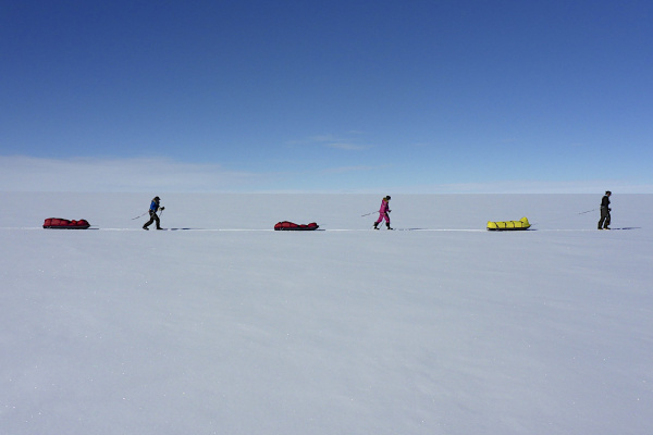
We are ready to go with sleds packed, skis on and an endless white plain ahead of us. We travel in single file, the team following in the tracks to conserve energy. And if you want to lead the group for a while we fully encourage it, in safe and uncomplicated terrain. It feels wonderful to have an unhindered view ahead, scanning the horizon for the first glimpse of the abandoned early warning station, Dye 2.
And then someone calls out, 'there's something on the horizon' and a debate ensues - is it Dye 2 or just a strong imagination? Ten minutes later it is unmistakable, Dye 2 takes shape, it's white radar dome glistening in the sunlight. The excitement is palpable and the pace picks up slightly, but there's no rush, it will take the rest of the day to reach it.
We continue eastward, slowly gaining altitude but we won't reach our high point on the ice divide for another few days. A quick break to drink from our thermoses and eat from our snack bags gives us momentary rest before we find our stride once again and lock into the polar plod, listening to the glide of our sleds, the swish of our skis and the rhythm of our hearts. Everything is in sync.
After lunch our objective is in clear view but distant clouds herald a change in fortune, we may be in for a blustery night. At 5pm we arrive at the station and it dwarfs our little team. It is an alien experience to see this strange shape, this relic from the Cold War era, perched on the snow, slowly being buried by each passing blizzard.
We quickly set up camp as clouds roll overhead, and, as we do every night, we prepare for strong wind. Thankfully, tomorrow is a scheduled rest day and a new forecast received on the sat phone is for the weather to clear by lunch giving us time to explore the mysterious bowels of Dye 2.
Inside our tents we light the stove and eat our remaining snacks as we wait for hot water to make a welcoming cup of soup. There's no shortage of excitement buzzing around the camp but a long day of sled hauling, full bellies and the prospects of a day of rest send us into a deep sleep, the kind you only get after such days on the ice.
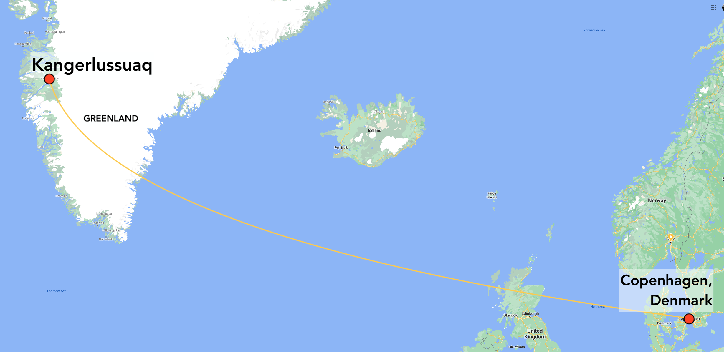
Flights
There are multiple airlines flying to Copenhagen, Denmark and then Air Greenland to Kangerlussuaq on the west coast of Greenland. We will advise you on the best flight options.
Once you have signed onto the trip you will receive a Greenland Crossing Information Booklet which has full details of how to plan for your trip.
What will be the temperature on arrival in Kangerlussuaq and during the trip?
The temperature will be anywhere from -10º to -30ºC, 14º to -22ºF
*
Where do we meet in Kangerlussuaq?
You will be informed where to meet based on your hotel and arrival time date. We recommend accommodation at Old Camp (you will find it online). We may also meet earlier in Copenhagen, depends on your schedule.
*
Can I leave bags in Kangerlussuaq?
Only if you decide return to Kangerlussuaq after the trip, as we don't return to Kangerlussuaq. This can be arranged with your hotel. Otherwise we post anything we don't take on the crossing to Tasiilaq on the other side.
*
How heavy will my sled be?
Approx 70kg, 155 lb.
*
What if I am not a skier?
You will need to spend some time learning how to use cross country skis. It is not difficult but a good technique preserves energy and makes for a more rewarding trip. Get some roller skis, take a course, join a pre-expedition training program in Norway.
*
What is the Guide to Client ratio?
1:6
*
Will there be any crevassing?
Greenland is a glaciated ice sheet and we negotiate some crevasses on the west and east flanks. Our guides are trained and skilled in glacier travel.
*
What type of sleds do we use?
We use lightweight pulks, 2 per person towed in a line. Spread across the pulks you secure your Polar Swag containing sleeping gear and some other items.
*
What type of tents do we use?
We use high quality Scandinavian tents, 4-person tents for two people. There is plenty of room to get comfortable but small enough to warm up quickly once the stove is operating. You are responsible for setting up, managing and taking down your tent.
*
What type of sleeping bag should I use?
A -30C down sleeping bag should be adequate, even warmer if you sleep a bit cold.
*
What will we eat on the expedition?
You can find our menu here
*
Who cooks the meals and melts the snow for water?
You do! This is a normal part of expedition life. We train you in how to use the stove.
*
What if there is an emergency and how will we communicate with the outside world?
We carry Iridium handheld satellite phones and stay in touch daily with our base in Oslo. We also carry a Personal Locator Beacons which can be activated in an emergency.
*
How long do we ski every day on the Greenland crossing?
The start through the icefall forces us to move slowly and steadily, it is difficult to make a lot of distance during these early days. But once we reach the plateau we start to build up our distance to around 25km per day across 7-8 hours of hauling.
*
Feel free to submit your own questions.